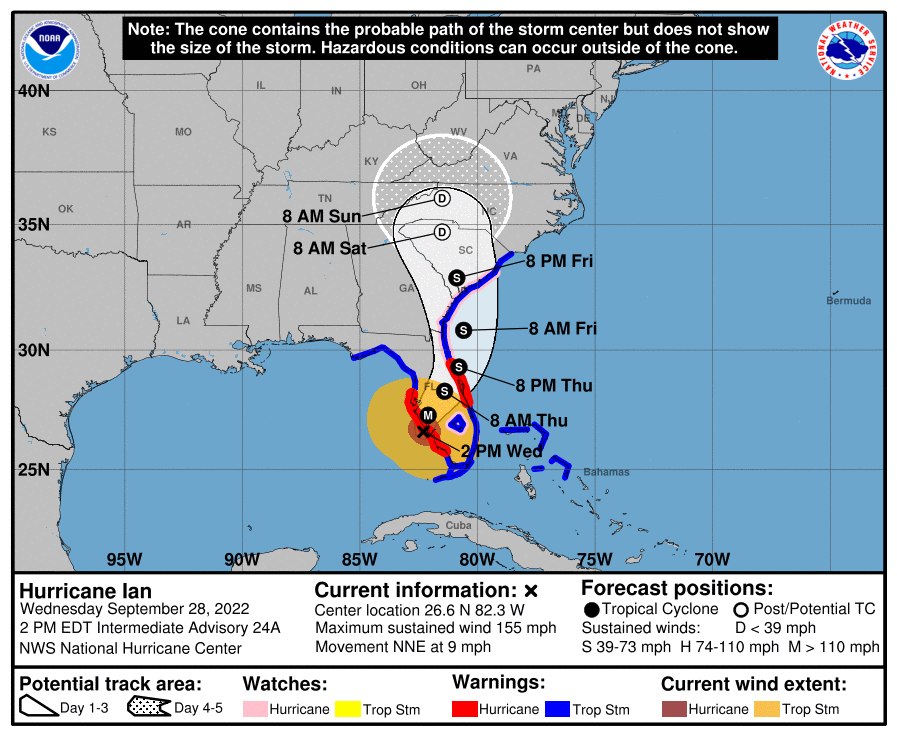
D: Tropical Depression – wind speed less than 39 MPH
S: Tropical Storm – wind speed between 39 MPH and 73 MPH
H: Hurricane – wind speed between 74 MPH and 110 MPH
M: Major Hurricane – wind speed greater than 110 MPH
IAN WILL CAUSE CATASTROPHIC STORM SURGES, WINDS, AND FLOODING IN THE FLORIDA PENINSULA.
A tropical storm warning remains in effect for Crystal River, Homosassa Springs, and Inverness. A Flood watch is also in effect until September 30th.
At 200 PM, the eye of Hurricane Ian was located by an Air Force Reserve Hurricane Hunter aircraft and Tampa radar data about 50 miles south-southwest of Punta Gorda, Florida.
Ian is moving toward the north-northeast near 9 mph (15 km/h). This general motion with a reduction in forwarding speed is forecast today, followed by a turn toward the northeast on Thursday.
On the forecast track, the center of Ian is expected to move onshore soon, move over central Florida tonight and Thursday morning and emerge over the western Atlantic by late Thursday. Ian is forecast to turn northward on Friday and approach the northeastern Florida coast in addition to the Georgia and South Carolina coasts late Friday.
Maximum sustained winds remain near 155 mph (250 km/h) with higher gusts.
Ian is a category 4 hurricane on the Saffir-Simpson Hurricane Wind Scale. Ian is forecast to make landfall on the west coast of Florida as a catastrophic hurricane soon.
Weakening is expected after landfall, but Ian could be near hurricane strength when it moves over the Florida East coast tomorrow, and when it approaches the northeastern Florida, Georgia, and South Carolina coasts late Friday.
Hurricane-force winds extend outward up to 45 miles (75 km) from the center and tropical-storm-force winds extend outward up to 175 miles (280 km). A River, Estuary, and Coastal Network station at Redfish Pass, Florida, recently reported sustained winds of 94 mph (151 km/h) and a wind gust of 126 mph (203 km/h).
The minimum central pressure is 937 MB (27.67 inches) based on Air Force Reserve dropsonde data.
RAINFALL: Ian is expected to produce the following storm total rainfall:
* Florida Keys and South Florida: 6 to 8 inches, with local maxima up to 12 inches.
* Central and Northeast Florida: 12 to 18 inches, with local maxima up to 24 inches.
* Eastern Georgia and Coastal South Carolina: 4 to 8 inches, with local maxima of 12 inches.
SURF: Swells generated by Ian are affecting the northern coast of Cuba, the northeastern coast of the Yucatan peninsula, and the west coast of Florida. Swells will increase along the east coast of Florida, Georgia, and South Carolina tonight and Thursday. These swells are likely to cause life-threatening surf and rip current conditions.
TORNADOES: Tornadoes are possible today and tonight across central and south Florida.
SURF: Swells generated by Ian are affecting the northern coast of Cuba, the northeastern coast of the Yucatan peninsula, and the west coast of Florida. Swells will increase along the east coast of Florida, Georgia, and South Carolina tonight and Thursday. These swells are likely to cause life-threatening surf and rip current conditions.
Crystal River Detailed Forecast