Live streaming in real-time from Marine Science Station
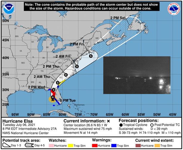
After weakening to a tropical storm near Cuba, the system restrengthened into a Category 1 hurricane as it approached Florida on Tuesday evening around 8 p.m. EDT with maximum sustained winds of 75 mph.
Elsa is projected to make landfall north of Tampa early Wednesday, and it has been rated a 1 on the AccuWeather RealImpact™ Scale for Hurricanes, due to the system’s expected rainfall, storm surge flooding, and the potential for damaging winds.
The center of Hurricane Elsa is about 100 miles SSW of Tampa or about 75 miles west of Fort Myers. The impacts remain the same across the area, however, with the Hurricane Warning remaining in effect for Pinellas and coastal Hillsborough County north and Tropical Storm Warnings south of Tampa Bay.
Hurricane Elsa Local Statement Intermediate Advisory Number 27A
National Weather Service Tampa Bay Ruskin FL  AL052021
853 PM EDT Tue Jul 6 2021

This product covers West Central and Southwest Florida

**Hurricane Elsa moving northward offshore the west Florida coast**


NEW INFORMATION
---------------

* CHANGES TO WATCHES AND WARNINGS:
    - The Tropical Storm Warning has been cancelled for Coastal
      Citrus, Coastal Hernando, Coastal Hillsborough, Coastal Levy,
      Coastal Pasco, and Pinellas

* CURRENT WATCHES AND WARNINGS:
    - A Storm Surge Warning and Tropical Storm Warning are in effect
      for Coastal Charlotte, Coastal Lee, Coastal Manatee, and
      Coastal Sarasota
    - A Storm Surge Warning and Hurricane Warning are in effect for
      Coastal Citrus, Coastal Hernando, Coastal Hillsborough, Coastal
      Levy, Coastal Pasco, and Pinellas
    - A Tropical Storm Warning is in effect for Inland Charlotte,
      Inland Citrus, Inland Hernando, Inland Hillsborough, Inland
      Lee, Inland Levy, Inland Manatee, Inland Pasco, Inland
      Sarasota, and Sumter

* STORM INFORMATION:
    - About 180 miles south of Cedar Key FL or about 70 miles
      south-southwest of Mouth of Tampa Bay FL
    - 26.6N 83.1W
    - Storm Intensity 75 mph
    - Movement North or 360 degrees at 14 mph

SITUATION OVERVIEW
------------------


Tropical Storm Elsa continues to threaten mainly coastal areas along
the west coast of the Florida peninsula. Elsa is expected to track
north over the eastern Gulf of Mexico just off the west coast of
Florida Tuesday and Tuesday night. This will bring a threat of
tropical storm force winds, localized flash flooding, storm surge,
hazardous marine conditions, and possibly a few tornadoes to portions
of west central and southwest Florida.

POTENTIAL IMPACTS
-----------------

* WIND:
Prepare for life-threatening wind having possible extensive impacts
along the west coast of Florida. Potential impacts in this area
include:
    - Considerable roof damage to sturdy buildings, with some having
      window, door, and garage door failures leading to structural
      damage. Mobile homes severely damaged, with some destroyed.
      Damage accentuated by airborne projectiles. Locations may be
      uninhabitable for weeks.
    - Many large trees snapped or uprooted along with fences and
      roadway signs blown over.
    - Some roads impassable from large debris, and more within urban
      or heavily wooded places. Several bridges, causeways, and
      access routes impassable.
    - Large areas with power and communications outages.

Also, prepare for dangerous wind having possible limited to
significant impacts across west central and southwest Florida.

* FLOODING RAIN:
Prepare for life-threatening rainfall flooding having possible
extensive impacts across west central and southwest Florida. Potential
impacts include:
    - Major rainfall flooding may prompt many evacuations and rescues.
    - Rivers and tributaries may rapidly overflow their banks in
      multiple places. Small streams, creeks, canals, and ditches may
      become dangerous rivers. Flood control systems and barriers may
      become stressed.
    - Flood waters can enter many structures within multiple
      communities, some structures becoming uninhabitable or washed
      away. Many places where flood waters may cover escape routes.
      Streets and parking lots become rivers of moving water with
      underpasses submerged. Driving conditions become dangerous.
      Many road and bridge closures with some weakened or washed out.

Prepare for dangerous rainfall flooding having possible significant
impacts across west central and southwest Florida.

* SURGE:
Prepare for life-threatening surge having possible significant impacts
across west central and southwest Florida. Potential impacts in this
area include:
    - Areas of inundation with storm surge flooding accentuated by
      waves. Damage to several buildings, mainly near the coast.
    - Sections of near-shore escape routes and secondary roads become
      weakened or washed out, especially in usually vulnerable low
      spots.
    - Major beach erosion with heavy surf breaching dunes. Strong and
      numerous rip currents.
    - Moderate damage to marinas, docks, boardwalks, and piers.
      Several small craft broken away from moorings, especially in
      unprotected anchorages.

Also, prepare for locally hazardous surge having possible limited
impacts across west central and southwest Florida.

* TORNADOES:
Prepare for a dangerous tornado event having possible significant
impacts across west central and southwest Florida. Potential impacts
include:
    - The occurrence of scattered tornadoes can hinder the execution
      of emergency plans during tropical events.
    - Several places may experience tornado damage with a few spots
      of considerable damage, power loss, and communications failures.
    - Locations could realize roofs torn off frame houses, mobile
      homes demolished, boxcars overturned, large trees snapped or
      uprooted, vehicles tumbled, and boats tossed about. Dangerous
      projectiles can add to the toll.

Prepare for a tornado event having possible limited impacts across west
central and southwest Florida.

PRECAUTIONARY/PREPAREDNESS ACTIONS
----------------------------------

* EVACUATIONS:
WATCH/WARNING PHASE - Listen to local official for recommended
preparedness actions, including possible evacuation. If ordered to
evacuate, do so immediately.

IMMINENT/ONGOING PHASE - Do not enter evacuated areas until officials
have given the all clear to return.

RECOVERY PHASE - Do not enter evacuated areas until officials have
given the all clear to return.

* OTHER PREPAREDNESS INFORMATION:
Now is the time to complete all preparations to protect life and
property in accordance with your emergency plan. Ensure you are in a
safe location before the onset of strong winds or possible flooding.

When making safety and preparedness decisions, do not focus on the
exact forecast track since hazards such as flooding rain, damaging
wind gusts, storm surge, and tornadoes extend well away from the
center of the storm.

If in a place that is vulnerable to high wind, such as near large
trees, a manufactured home, upper floors of a high-rise building, or
on a boat, plan to move to safe shelter.

If you live in a place particularly vulnerable to flooding, such as
near the ocean or a large inland lake, in a low-lying or poor
drainage area, or near an already swollen river, plan to move to safe
shelter on higher ground.

Always heed the advice of local officials and comply with orders that
are issued. Do not needlessly jeopardize your life or the lives of
others.

When securing your property, outside preparations should be concluded
as soon as possible before conditions deteriorate. The onset of
strong gusty winds or flooding can cause certain preparedness
activities to become unsafe.

Be sure to let friends and family members know of your intentions for
weathering the storm and your whereabouts. Have someone located away
from the threatened area serve as your point of contact. Share vital
contact information with others. Keep cell phones handy and charged.

Check on those who may not be fully aware of the situation or who are
unable to make personal preparations.

If you are a visitor, know the name of the county or parish in which
you are located and where it is relative to current watches and
warnings. If staying at a hotel, ask the management staff about their
onsite disaster plan. Listen for evacuation orders, especially
pertaining to area visitors.

Closely monitor weather.gov, NOAA Weather Radio and local news
outlets for official storm information. Listen for possible changes
to the forecast.

There is a threat from tornadoes with this storm. Have multiple ways
to receive Tornado Warnings. Be ready to shelter quickly.


* ADDITIONAL SOURCES OF INFORMATION:
- For information on appropriate preparations see ready.gov
- For information on creating an emergency plan see getagameplan.org
- For additional disaster preparedness information see redcross.org

NEXT UPDATE
-----------

The next local statement will be issued by the National Weather
Service in Tampa Bay Ruskin FL around MIDNIGHT EDT, or sooner if
conditions warrant.